A Career in Maritime

11/14/2020

I want more diversity in my field. I want to work with black/brown people, queer people, immigrants, and people of different mindsets from different backgrounds. I want my entire work community to be more inclusive. We can jumpstart this process through sharing our own stories and information with people who want to hear it. We can be better operators in a better industry by making this effort in bringing diverse perspectives and contributions to our workplace.

Madeleine is helping me (@madeleine) with the video and presentation.

Some suggestions for a video:

  1. What position do you currently hold? How did you come to be in this field
  2. Advantages of maritime (family, free time, “see the world”)
  3. Hitch length location, other time commitments, holidays, vacation
  4. Advice for someone looking to learn more, where to start
  5. Favor us with a fun sea story!
  6. Is there anything else you’d like to tell high school kids watching this video?

Some other pointers:

  • Don’t have private company stuff in the shot with you; you may have to deal with your companies legal department.
  • Upload your videos to Google Photos and share a link to the video to my gmail mrdrewk@gmail.com. There are Google Photo apps for both iPhone and Android.

I will involve you in the ongoing project so your contribution remains accurate. I will submit the final video and presentation-outline to you for approval.

drew@kerlee.com

OpenCPN on Android

Download and install OpenCPN for android here

Download and unzip chart files to some spot on your phone. Raster – pictures of traditional charts, Vector – electronic version. If either of the links break, search “chart downloader noaa rnc” or “chart downloader noaa enc.”

Open the app, go to settings (wrench in top left) > Charts > Chart Files. Add Directory. Point it to the location you unzipped the chart files.

Click the button on the bottom, “Force Full Database Rebuild” and Bob’s your uncle.


Other reference for TRANSAS on Android, but since that article 4/2017, TRANSAS android app has been up and down. The accompanying chart store has been hit or miss. While their raster charts are superior to NOAA, it just hasn’t been worth the hassle or expense (about $15 per area) they charge for the charts.

PSA: NOAA charts are free. Enter OpenCPN. When I was initially trying out this app, it was wonky. As of the current version (4.1.1028) has been worth the switch.

OpenCPN website

There isn’t an official OpenCPN app for iPhone, looks like SEAiq is the equivalent version. But as I recall, TRANSAS iSailor app, was geared towards iPhones, and that would be your best bet.

Another offline vector map app, OSMAND, has a marine version, but it’s junk. The street maps are pretty darn good, and editable by anyone.

Tacoma’s LNG Plant

I have mixed feelings about an LNG plant in Tacoma. But generally, I think we should go for it.

biases

I think I’m in a unique position to research and write commentary on this as I’m a tugboat captain working in Seattle and Tacoma. Docking ships, container ships, oil tankers, and LNG tankers (if that happens) is my bread and butter. I have two cars a ’97 Toyota Camry (26mpg), and a ’13 Nissan Leaf (all electric). I ride bikes, I recycle, and I truly care about my environment and the impact that I create living here. I would have voted for Bernie; I ended up voting for Hillary. I’m an inactive member of Citizen’s Climate LobbyIndivisible Tacoma, and People Power ACLU. So there are my biases.

I’ve worked on tugs in Valdez AK doing exclusively oil tankers, and all the required support that goes with that. I’ve docked ships in San Francisco, LA, and now Seattle, Tacoma, and Ferndale (near Anacortes). A couple of days ago, we loaded 15,000 gallons of diesel into my tugboat.

Pipeline vs truck

Valdez harbor is the terminal end for the 400 mile famous Trans Alaska Pipeline. This pipes crude oil from the North Slope of Alaska, and is a major producer of domestic oil. At the south east corner of the bay, is Petrostar refinery map. They make diesel fuel, among other products, from Alaska crude, which is right down the road.  Petrostar does not have a dock. There are fuel storage silos to the west of Valdez map, where fuel is stored uphill from a fuel dock. The water is probably too shallow over by the refinery, so it would be super expensive to put a dock there. Diesel needs to get from Petrostar to the silos so they can fill tugboats, and barges, that, in turn, fill and work the big ships that call on the port. There was a plan to build a pipeline from Petrostar, around the east side of The Bay (ccw) to the storage silos and fuel dock. But the pipeline would’ve crossed through wetlands that are delicate and home to lots of wildlife. The plan was nixed for that reason. The only fuel dock and their silos still needs fuel to sell as the only game in town for miles – so instead of a pipe, they drive trucks back and forth.

This brings up some obvious problems. The diesel still has to get from A to B. The town of Valdez had the option to move that oil via trucks on the road (road already there) or pipeline. Other places will have water (ships or barges/tugs) and rail as options.

Tacoma, and the country, depends on internal combustion engines. And much bigger IC (internal combustion) engines on the ships in our harbors. Our working waterfront isn’t going anywhere any time soon. When a ship pulls into berth (it’s parking spot) they shut down their main engines. They’ve also got at least one tractor sized engine running to generate electricity. If the ship plugs into shore-power, they can also shutdown those generators, which brings at berth emissions to zero.

Puget Sound Energy LNG webpage specifies not going into the LNG export business. They are going to be an LNG fueling station for ships that call on our port. As LNG hasn’t been used as an industrial fuel until recently, this will bring less polluting, newer and cleaner ships to our port. Tote runs ships in and out of Tacoma, and have promised to be the first, and probably biggest, customer of the facility.

I used to think that the green energy evolution will be naturally driven by gas prices. When crude oil gets too hard to find, or expensive to drill, gas will get more expensive. When prices creep up to $20/gallon, electric cars that cost pennies per mile will become far more attractive. But recently, I’m starting to think this capitalistic idea might not be fast enough. By the time gas does reach $20/gal, our environment may have already gone through irrevocable changes. The price of gas is much more complicated than supply and demand.

I’ve seen the argument “we should stop investing money in petroleum.” Well that’s simply not correct. Our entire transportation infrastructure would grind to a halt without liquid fuel and the internal combustion engine. I hope that bit by bit, people will start to drive more economical cars, and think about creating a smaller carbon footprint with their own life decisions.

Barring any fast-acting major catastrophe, half measures and small steps are the only kind of progress we’re going to make towards a cleaner future. LNG is the cleanest petroleum product out there. Promoting it through a Tacoma facility is another small step towards greener energies, and I’m proud Tacoma is at the forefront.

my response to Tacoma Tribune op-ed

This op-ed was written by the PSE LNG PR guy (there’s some acronyms for ya).  There are some good points in there that I’ll draw out here:

  • “…risk of explosion and dangerous chain reactions.” Of course this stuff is dangerous. When you use it properly, you can heat home home with it, and many other uses. If it wasn’t dangerous it wouldn’t be helpful! But is it more dangerous than gasoline? It’s different.
  • “…39.6 tons of air pollutants the plant will emit every year. What they don’t talk about are the 160,000 tons of toxic air pollutants the LNG plant will eliminate compared to the fuels used today.” An LNG plant anywhere will have an impact on where it is. If it’s up in Ferndale, it will still put out 39.6 tons in Washington’s air. I’d like to look at the PNW as a whole. Having an LNG facility will bring less polluting ships here, vs current, diesel burning ships. That will reduce overall emissions in the area.


Other interesting, possibly related notes

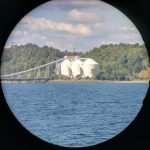
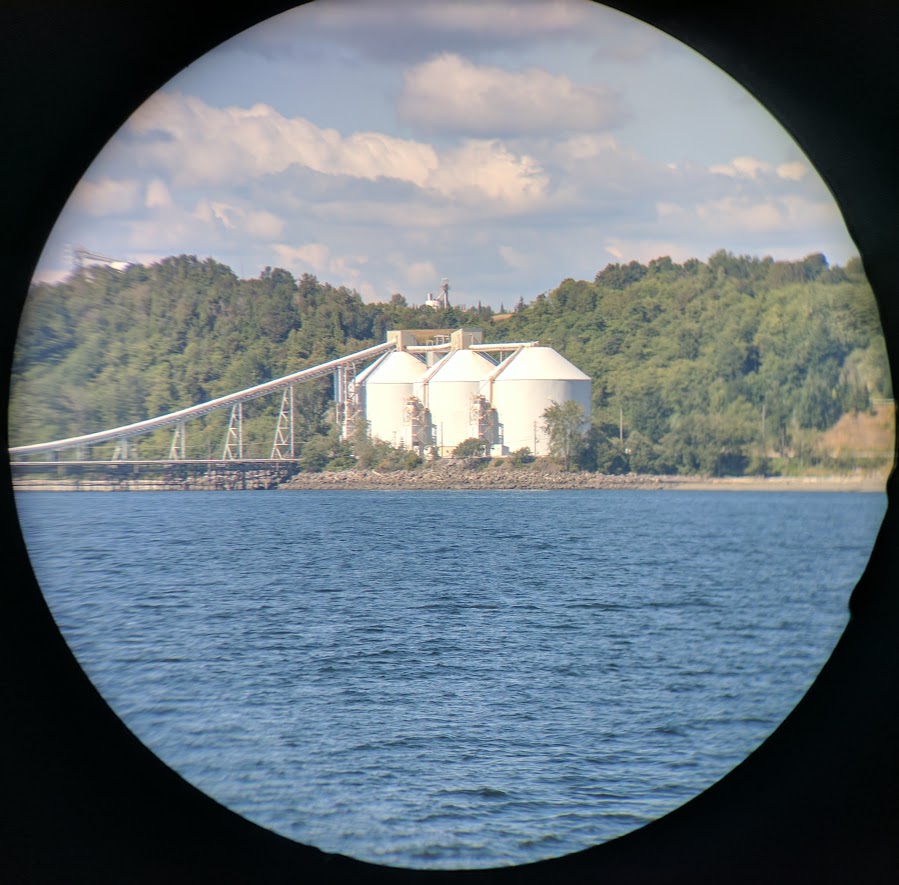
Washington already has an LNG depot right here. From what I’ve heard (and can see from google maps) it’s small, and only takes two ships per year. Here’s a pic I snapped of it through some binoculars yesterday.

I sat next to a guy who worked at California’s energy provider PG&E. During the winter months, locations of PGE gets natural gas (NG) via pipeline from who knows where. These small pipelines are able to move more NG than Californians require through winter. They store the excess underground in naturally occuring depleted reservoirs. In the summer, when energy demands outstrip the pipelines, they draw the stores back up from those reservoirs. That totally blew my mind. They just pump it back into the ground! A few years before they’d drilled it and drew it all out of there.

LNG is the cleanest burning fossil fuel.

Liquefied Natural Gas is 1/600 the volume of Natural Gas. LNG must be colder than -259F. LNG boils at -259F. Water boils at +212F.

Think about making a gallon of gasoline the size of 1 teaspoon, that’s LNG. (1 gallon = 726tsp)

When a liquid changes state to a vapor, it sucks up heat. That’s called latent heat. Your body does the same thing with sweat. You get hot, you get wet, that water evaporates: boom, you cool off due to evaporation. So, you’ve got this giant tank of LNG, and it starts to get “warm” up to -260F. The parts that hit -259F boil, and change into vapor. That state-change sucks heat out of the system cooling the tank again. This is called auto-refrigeration. The boiled off LNG does increase in volume by 600 times, so you gotta do something with that too. Storage facilities will grab it, and burn it for energy to either cool the tank via the mechanical refrigeration, or run other electrical service.

LPG liquefied petroleum gas. It is produced as a by-product of natural gas processing and petroleum refining. Heavier than air, will evaporate at room temperature and pressure. This can make it more dangerous. Some forklifts will have a can on back of LPG, and can be driven indoors. You may have smelled one at the hardware store etc.

CNG compressed natural gas, comes directly from underground. It usually stored in high pressure tanks, 3600psi. It’s lighter than air, so if there’s a leak, it just dissipates. This makes it safer than gasoline, or heavier than air gasses.

Propane is a type petroleum gas. It can be liquefied at normal temperatures, and moderate pressures but will vaporize at normal temperature and pressure. It’s a liquid in the green Coleman can, but turns to a vapor when you’re boiling water with it. It’s heavier than air, =dangerous. wikipedia

Ships and the water are the most efficient way to move cargo. If you put the containers from a large ship on a train, it would be 44 miles long. While ships and their engines are a big single point pollution source, they are far better than 5500 trucks.

The cost to transport a bicycle from Thailand to the UK in a container is about $10. The typical cost for shipping a DVD/CD player from Asia to Europe or the U.S. is roughly $1.50; a kilogram of coffee just fifteen cents, and a can of beer – a penny.

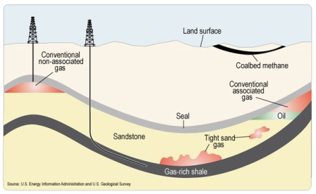
I grabbed this image from a energy company “children’s” webpage. It really understand where this stuff comes from. Remember that “gas” as used here is Natural Gas, and gasoline comes from the refining of crude oil (crude in this pic).


bibliography

Transas iSailor on android

iSailor for android started off pretty crappy, but with the latest version (2.81 1/18/17), I’ve found it’s finally made it over the hump to make it actually worth the money. Like many other apps, the app is free, but be prepared to drop about $50 to make it sing. I paid for West Coast CA charts ($6), NMEA ($11), and AIS receiver ($12) input sensors.

If you have a device broadcasting NMEA data (course, speed, position, AIS targets) on your boat wifi, you can point iSailor’s NMEA and AIS Receiver at that IP. The easiest way to get the address of the server computer is to install the “Fing” app. There are both android and iPhone flavors available and functionality is the same. Hit scan for the current wifi you’re on, and look for the IP of the server, should be something like 192.168.0.166. Also specify port 23.

Open up iSailor, hit TOOLS > Sensors > AIS & NMEA Connections > Connections > Add Connections. TCP type in the IP of the server (eg: 192.168.0.166) and Port 23, Save. Back under TOOLS > Sensors > Primary PS select NMEA. Your position and AIS targets should all pop-up.

Here are all the pics I’ve got showing parts of the process, but didn’t fit nicely above.

Senior Cruise Begins

Things on cruise have been going pretty good. I’ve been busy standing
the 04×08 watch, and the 16×20. So it’s from 4-8AM and PM. We call ’em
mirror watches. I’ve spoken with Alison about watches, and she’s a fan
of the 04x08s as well. I sometimes find it a little hard to get much
sleep between these watches though! I would need to get into bed at 2000
(800PM) and be asleep right away so I can wake up at 0310 and get
dressed and assume watch at 0345. Early mornings for sure. But it’s nice
to catch the sun rise and sunset. Magically, by the time watches roll
around again, I’m fairly re-energized and ready to stand the four hour
watch.

Recently I’ve been standing as the cadet watch officer CWO. As the CWO I
run the bridge, radars, electronic charts, our vessels cross track
error XTE our left/right distance from our intended track line. I
maintain the ship’s logbook, do weather observations, and stand a look
out incase other vessels come near. We’re certainly out in the middle of
the ocean now though! I haven’t seen any vessel, or even caught an
electronic beacon from another vessel in about three days. And we can
sense stuff at around a 50 nautical mile radius! A lot of big blue out
here.

Celestial navigation has been a real challenge, and fun too. I’ve been
using my sextant everyday. Up until today, we’ve been overcast much of
the time. That has made shooting moon, stars, and even the sun
difficult. There are two main goals with celestial navigation. First to
fix your position in the ocean to a spot within 5 nautical miles of your
actual GPS reported position using nothing but your brains, a few
reference books, and your sextant. The other goal of c-nav is to figure
out how much error your gyro compass has. A regular compass uses Earth’s
magnetic field to point to (near) north. Our gyro compass simply point
in the same direction we point them in when we turned them on. When we
turn them on, we always point them at true north. As the voyage goes
one, eventually even the best of gyro compasses begins to wander off
true north, and we need to determine that by comparing the direction of a
celestial body appears to be (by the gyro compass) and the actual
direction to that body we calculate by our brains and books. While a
small part of celestial navigation is very romantic, 90% of it is number
crunching! Ah well.

I have one more watch as CWO this evening at 16×20, then we’re off to
“professional training” next week. I’m looking forward to switching it
up a little bit, getting regular sleep, and doing stuff that isn’t quite
as difficult as running a bridge of the TSGB.

End of commercial cruise – leg 1

It’s been a great trip! I got to see some really neat stuff, and I wanted to leave you guys with a few pictures

images
I’ve recently been initiated into the secret tradition of shellback. It was a disgusting ceremony, and I can say with certainty, that I’ve earned my shellback-dome. No more polywogg initiation for me! Ever!

DSC_0732sm
The tortoises on Galapagos were terrific!

DSC_0797sm


This shot was taken by Eric when he was ashore on Wolf Island. That is a very small island right here. I’m pretty sure that’s a baby boobie bird.

DSC_0775sm
There I am waving “hello” but in this case goodbye,DSC_0539sm

and it wouldn’t be complete without the perfunctory sunset picture.

Until next time!

Galapagos – liberty time!

So, when ships go to the shore, the sailors get dressed up in civvies (civilian clothing, but we’re not military, they just call it civvies) and go ashore for liberty, or leave. Liberty is just time where you can do what you want! Usually this frosty adult beverages. What will generally happen is the crew piles into a small boat for a ride ashore. As soon as that little boat hits shore, it’s like a small explosive under the pants of each gussied up sailor goes off, and they all explode onto shore in almost perfectly opposite directions from each other. It’s totally weird.

This time, as we only had two days in Galapagos port, the chief scientist was nice enough to organize a guided tour of The Highlands. Our guide was terrific, and took us to the Darwin Foundation visitors center. It was great to see the tortoise breeding program that they have there. One of the more harmful invasive species on the islands are rats. They clearly came over from ships, and those rats will kill and eat just about anything their size. As a result, baby tortoises were being decimated, and the population was quickly declining. The Darwin Foundation started a breeding program where they take the fertile eggs from the nest, and let them hatch and grow in their protected cages until they reach the “rat proof” size. At that point, depending on the colors of the numbers on their shells, they’re returned to their respective islands to live their lives.

As each of the islands is pretty separate from one another, there are different sorts of species of tortoises on each island, and sometimes even in different valleys. Until the advent of dna testing, the definition of species had been pretty vague. One part of a specific species is that one is not capable of reproducing with another. There are many exceptions to this rule (mules, and more) but that was one guideline as to weather this creature was it’s own species or not. Now with dna, it’s something easy like any less than 95% similarities = new species. But I think humans are something like 98% the same as pigs… there’s a possibility I screwed up my numbers 😉

DSC_2247sm

This is Lonesome George who is the last remaining of his species. The guide was excited to see how happy George was that his keeper was in the pen with him cleaning stuff out.

More interesting facts on the Galapagos: all the species that ended up here had to get there on their own. Because of the long distance they had to go, this usually meant they had some close connection with the sea, and were genetically simpletons. I remembered that with humans, we need a certain number of people to form a critical mass where we get enough genetic diversity that we can begin to reproduce and make future generations that are different enough from each other so they don’t get inbred. Genetic simplicity means that one male, and one female, or one pregnant female can show up, and even her offspring can make more of them to sustain a population.

DSC_2230sm

Galapagos famous swimming lizards. They can stay underwater for long periods of time, but as the water is too cold for them, they have to spend a lot of time sunning themselves on the rocks (also hence the black color) to bring their body temperature back up

DSC_2219sm

A boring picture with out an explanation:
ever heard the word “polywogg?” Well, it’s a term for someone who has never crossed the equator before. Or if they have, they have not been through the equator crossing ceremony. Luckily for me, we’re going to have an equator crossing ceremony, so I will loose my polywogg status before the end of the trip. The ceremony can be many different things, but it’s basically hazing as I understand it. I’m sure there will be many follow up hilarious pictures to add!

Oh so the picture: see the gps how it says: 0degrees 00.0001’S? Well that means I’m very very close to the equator by that gps’s estimation. Exactly 1/1000 of a nautical mile (6 feet). As one get’s closer to the north pole and Santa Clause, the S or N (latitude) will get closer and closer to 90 degrees. Each degree is divided into 60 minutes. Each minute of latitude is equal to 1 nautical mile (=1.15 statute miles you’d measure in your car), then from there we got to 10ths, 100ths and 1000ths of a minute.

DSC_2284sm
tortoise in the “wild”, huge aren’t they?!

Wolff island

So there’s this really small island north of the regular Galapagos – well there’s two: Darwin, and Wolff. Today, we sent a few scientists ashore to put some sort of GPS tracking device on the island. Apparently, it had never been accurately pin pointed on maps/charts so that’s what they’re off to do. I’ll see if I can get some pictures of the thing, sounds interesting.

google map

IMG_4436_sm
This shot is of me, chief mate Chris, and os Rob. We’re just waiting around for some anchor operations to leave the port at Galapagos

IMG_4481_sm
Here we are getting ready to go on our small boat ride out to see Wolff island up close.

Ah, they did get an interview of me up there:
http://galapagos-expedition.blogspot.com/p/crew-corner.html

The reason they went to Wolf island was to do a geology survey using some nifty gps technology. As I understood gps, the us government didn’t want people using their signals for super accurate tracking which could be used for guided missiles – so they embedded a mistake in all the tracking codes which is the main reason why, when you’re standing in one spot with your gps, it sometimes says you’re moving around. Apparently, now there is a second signal the is broadcast out that can be accurate to millimeters, but to get a fix of that accuracy, it takes about 10 minutes of not moving. Useless for guided missiles, but perfect for measuring small movements on slow moving things, like Wolf Island. Movements like this used to be measure with lasers, but even lasers had some built in errors, as the temperature of the air would change and distort the light. Some of which scientists could get around by shooting a red, and green laser. But even then, only accurate to a few millimeters. Now, with this new fangled gps technology, that sort of movement measuring is going away.
reason for going

Wolf Island looks very white from a distance off. It’s all the bird shit. Amazing.
another bird
these two pictures are both from galapagos-expedition.blogspot.com

A picture tour of Melville

Did a bit of a picture tour of the ship. I took many pictures, but I’ll just put the real interesting ones up here.

dsc_2152
This shot is of a swath of the bottom of the sea. It looks colorful: but the colors simply represent the different depths of parts of the ocean floor. We’re going to be driving back and forth along the bottom (“mowing the lawn”) until they have a full topographical map of the bottom out here: one very expensive map!

dsc_2144
Here’s a shot of me with the third mate (3/M) on board. Funny that his hair looks wet, it’s because he’s in the HOT TUB.

dsc_2154
a sample chart of the approximate routes that we’re going to be following while driving around out here making the map of the bottom.

dsc_2157
here’s me on the bridge of R/V Melville. See! I get to wear what ever I want here, and I haven’t shaved for two days. Amazing research vessels…

dsc_2158

Ship’s library. Turns out I didn’t need to bring ANY books, there are thousands here already.

dsc_2179
Here’s my room. You can see that there is double storage, as the room is supposed to have two people per room, but I’ve got the whole thing to myself. There to the left of the laptop is my “cruise assignment.” It’s a big assignment, so I made a summary of the project, and printed it out so I could stare at it whenever I feel lost. I do a lot of staring at it. To the right of the dresser on the bulkhead (wall) you can see my whiteboard for daily stuff I need to take care of, and below that a little calendar that I made counting down the days. I’m not in any rush to get off, but I like to know how much time I have left!

dsc_2191
The ship has 3 large Caterpillar and 1 small(er) Caterpillar engine. All four engines make electricity which is piped (I say piped because the cables are really big) to the “motor” room in the aft of the ship. Interesting point here: an engine has internal combustion, makes locomotion from fuel on it’s own, whereas a motor changes external power into motion. So these diesel engines make electricity for the big electric propulsion motors.

dsc_2181
So Melville is a research vessel. Two of the main things they do are: tow some sort of instrument behind them, and lower instruments down to the bottom of the water. Currently we’re towing an MR1 from the University of Hawaii (http://www.soest.hawaii.edu/HMRG/MR1/), and when we’re finished with that project, we’re going to be doing some dredging of rocks and dirt from the sea floor. These two very large spools of cable have a Safe Working Load of about 30,000lbs and will have the dredge (old picture of a very similar dredge we’re using) jaws/net lowered to the ocean floor, then drug along to pick up rock and sediment samples.

dsc_2202
Here is the engine control room. They don’t really have any windows – I’m glad I don’t have to work down there!

dsc_2203
The funny thing about the control room is that it’s facing the stern of the ship. I was told that this wasn’t normal, but the engineers here seem to think it is normal! Just so everyone is clear: STBD=starboard=right, PORT=left. Ass-backwards!

dsc_2160
our messdeck where we eat all our meals

dsc_2167
a shot of the galley. You can see the fryer, the grill and a few ovens. This galley wraps around to the back with more stuff on both the island and around all the walls. There are two cooks June and Richard: they’re fantastic!

dsc_2168
if I’m not hanging out in the library, or my rack, I’ll probably be trying to find some brainless, interesting dvd in the lounge between meals or something.

dsc_2209
Me with one of the Galapagos islands in the background. I think this one is called Pinta, like one of the three Columbus boats. No idea if there’s any connection there…

Well, that’s all for now my friends. More to come later,
drew


Commercial cruise: first installment

It’s now three days into my commercial cruise with Scripps research vessel: Melville. As I’d hoped, there are some truly friendly people that I get the pleasure of working with, both on the deck side of the operation, engine side, and the science crew. This vessel, R/V Melville is certainly one of the more laid back commercial vessels I’ve ever worked aboard. We’re allowed to stand watch in shorts and t-shirts:even more laid back than the law office in Hawaii (on days when clients came in anyways… I doubt I could get away with board shorts, and NO shirt on watch!).The captain, and a few of the mates even listen to music while they’re on watch. We do have an honest to god hot tub aboard. It’s made of plywood, but it’s got jets, and hot water and the whole thing. I haven’t seen it in use yet, but I’m sure someone will get it going soon enough. There is a mysterious pipe coming up from the engine room where they dump warm water into the tub, then just drain the thing right over board when the soakers are finished.

Everyone has been really helpful and interested in my commercial cruise project. Unfortunately I have not been sent out here with the easy task of: learn a lot, ask questions, and have a great time. I have to document everything, and go through an entire 43 page assignment from school. There are different aspects of this assignment, but primarily they cover: drawings of the ship and her systems, 16 short essays explaining different operational aspects of daily life, and loads of check offs for skills. Now that I’ve started to really get my head into this project, I’m realizing it probably will take the entire 60 days! I’ve got pieced printed out, and taped to the bulkheads (walls) of my cabin so it’s literally looming around me all the time. I’m already taking great pleasure in crossing things out!

Costa Rica has been a very warm climate. Many of the crew have been on board for months already, so they’re always itching to get off the ship and go zip lining or hiking, or simply drinking. I’ve been pining for this trip ever since I got here, so I was  disappointed that they forced me to take some time off and go ashore. It turned out just as well, I’d forgotten my wrist watch and needed to purchase one at a store.

The other part of this commercial cruise is beginning to get a taste of what it’s like to work professionally aboard a ship. Because I’m “cadet Kerlee” it’s okay for me to privately ask the crew what they’re making in their positions. I rare opportunity for sure – but information that I think is important when deciding on where I want to set my sights for after graduation. There are four positions in each engine and deck departments that are below a third mate. For the deck side, they are AB/OS, for the engine side WIPER/OILER. Many of those positions have been filled by recent academy graduates who weren’t able, or willing, to take work aboard a different vessel on their actual third mate license. The two main reasons I chose a research vessel for my commercial cruise are:

1. they have a mission that is based in science

2. diverse friendly small crowd of people to work with

Other ships’ mission may be simply money. Other ships often operate with as small of crews as possible, which usually means the same 12-15 crazy old men day in and day out. Working for a university (University of California, San Diego SCRIPPS) with science as the primary goal is a terrific way to get a start in the maritime field. The way the US Coast Guard licensing works out, once I get my 3d mate license, then 2nd mate and so on, it’s easy to work aboard one ship, then another, and to move around. That gets back to one of the reasons I chose boats in the first place: itchy feet! The world is a staggeringly large place – the ideal job will take me to cool places.

Ah, some of the undergrad scientists have put together a blog chronically their science adventures on our trip. Probably will make for interesting reading as well:

http://galapagos-expedition.blogspot.com

I’ve blathered for long enough – until next time,

drew